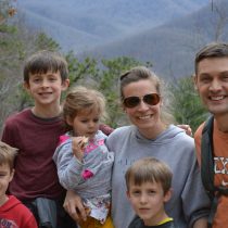


If you followed my insta account during June 2021, you saw our families tour of the West/Southwest Coast and several National Parks. Several individuals have asked for the itinerary, so I thought I’d share here for easy access, along with my ‘post trip’ thoughts.
If not planning on travelling for a month, this itinerary would break out quite nicely into four separate week to 10 day trips. One leg would be the Yosemite & Tahoe portion. A second full week could be San Fran/Wine Country/Big Sur area. You could do Joshua Tree, the Coachella Valley, Sedona/Flagstaff as another leg, and the final leg being the main National Parks of Grand Canyon, Bryce, Zion, Arches, Buckskin Gulch, etc…
I legitimately started planning this trip close to a year out. Which turns out to be almost necessary, when trying to book accommodations within the National Parks, as capacity is limited. I was SO thankful we had booked accommodations within Yosemite, to drive in/out would tack on an additional close to 3hrs of your day, as the nearest ‘outside’ city, where you could book a hotel or B&B, is roughly an hour and a half drive to get to the infamous “Yosemite Valley”. The park is insanely huge. Like impossible to wrap your mind around until you’re there, driving in it. Staying in the valley also allows you to forego waiting in lines to get into the park, or the concern it could reach capacity. We stayed in the Curry Village white canvas tents. A step up from ‘true’ camping, in that you have a comfy bed/pillow, and they provide linens, so you don’t have to pack. However, you can hear EVERYTHING around you, so if you’re next to loud campers, babies, or party animals, plan to bring ear plugs to help you sleep. There are heated tents, though in June I thought going with the unheated option would be fine. It was still quite cold at night. They give you wool blankets, so with that and a hoodie, I was perfectly fine, but the kids that kick all their covers off in the night, did say they got cold. There are cabins and a true hotel if you’re looking for a little more privacy, or legit camp sites if you have the ability to pack all your gear with you. Waterfalls are at peak capacity during the late May timeframe (we went over Memorial Day weekend) as the snow runoff continues, and the waterfalls there were absolutely INCREDIBLE. Definitely recommend that timeframe for perfect weather/waterfall conditions.
The drive from Yosemite to Lake Tahoe, along State Route 4, was absolutely incredible. While the drive itself, if you keep moving, should only take ~5hrs…. I would almost plan a whole day so you can make stops, take additional hikes, and enjoy the route. I did not look up hikes along the way, cause I had no idea it was going to be so beautiful. Kevin and I both agreed, you could easily decide to drag the drive out for 2-3 days and camp at a few sites along the way, before continuing on to Lake Tahoe.
Understanding most people might not be able to swing traveling for a full month, the Yosemite/Lake Tahoe portion would be a SOLID 7-10 day experience all on it’s own. Fly in and out of Reno, if you decide to do it this way, and start in Tahoe, and drive into Yosemite from there.
The Big Sur/Monterey/Carmel-by-the Sea portion was beautiful, remote, and a fun time to be completely disconnected from the world, with such limited wifi. Having grown up with Lake Michigan Beaches, and East Coast ocean beach experiences, I was disappointed the wind/cold water really didn’t provide the ability to ‘sit on the beach, read a book, play in the water’ experience. It’s gorgeous to look at, but the rocky cliff made most parts of the cost inaccessible, and the parts we got too were very windy, and we all know how well kids deal with sand in their eyes ;). The town of Carmel by the Sea was the quintessential sea side town, with incredible shops (very pricey, so we just looked) to wander through. There were a ton of art galleries, which were fun to explore, albiet a little nerve wracking to explore with kids. I kept saying, “Remember, we look with our eyes, not our hands”….. as the gallery owners would let them know they could touch it if they wanted it in their bedrooms. YIKES! My favorite experience here was exploring Point Lobos State Park, and then having dinner at The River Inn, where we got to sit IN a river in these great Adirondack chairs while we enjoyed our meal, and the kids were able to explore and catch minnows when they were done eating.
Heading to Palm Dessert and the Coachella Valley from there was DEFINITELY a shift in climate. The cool, climate controlled, pacific coast that always had a cool breeze, shifted to stifling desert heat with no breeze. Absolutely to be expected going in the summer months, so I had no illusion that it would not be HOT. I’m SO thankful we went on this trip IMMEDIATELY after kids got out of school, as it only got hotter. Given this was part of our loop, it worked in our favor that this was a work week, as it gave the kids some down time to rest/relax before the final week of hiking, and I didn’t mind being indoors with AC when it was that hot out. However, for those not doing the month loop, this part along with Sedona/Flagstaff and exploring more of that Southwest area would likely be MUCH more enjoyable say over a Thanksgiving break or Spring break in late March. Sedona was incredible, and I was totally bummed we only had one full day there, definitely gonna get back out that way at some point to explore more.
I was also REALLY glad I had spent so much time researching hikes ahead of time. Travelling with kids, is not when you want to be building plans on the fly, when the peanut gallery call all weigh in. Having the list of spots I wanted to target on the itinerary, really helped ensure all I had to do day of was put the address into GPS and off we went on our next adventure. In regards to packing, I was very intentional to make sure we had all the gear we needed to minimize whining. Knowing how much hiking we’d be doing, we decided to invest early in solid hiking shoes the kids could all break in a couple months before we went. I could TOTALLY tell the difference from legit hiking shoes vs. the tennis shoes they normally ‘hike’ in around home, because we barely had any ‘slips’…. Selah called them her ‘grippy’ shoes, because she could navigate climbing all these rocks without slipping, which was huge in avoiding skinned knees, sprained ankle’s or much much worse. I also made sure we had camelbacks for everyone, so Kevin and I weren’t carrying the water for the whole family. Our packs were saved for other ‘extras’ I wanted to be sure we had, like lots of snacks to avoid the “I’m Hungry” complaints, band-aids and moleskin to address anyone feeling a blister coming on, a compact picnic blanket should we need to rest, back-up batteries for my camera because…. hello…. can’t risk missing THE SHOT :).
At the end of the day, I can take credit for the hard work I put into planning it, but give ALL the credit for the final experience to God…. and not in the corny, trite, to God be the Glory….. but legitimately feeling so seen, and loved by Him through this all. Mom’s get it. We can try our absolute best, and sometimes the best laid plans, just blow up in our faces. Travel delays, weather issues, sickness, kids acting a fool, dealing with the human race at large…. outside of your procured/known bubble of experience….. there are a LOT of points of potential failure in our everyday existence. I had a TON of anxiety leading up to our departure, around ALL those potential points of failure….. Pointing out the obvious weakness of my own faith still…. that its ALL ON ME to make this life work, and any failure is my failure… doh! So when EVERYTHING works out, kids get along, travel connections go off without a hitch, weather is working in your favor, no issues with reservations/accommodations, the time planned in each stop is just enough so that you get the full experience without feeling rushed, but are ready to be done when it’s over….. You recognize the miracle for what it is, and give thanks.
I am a true subscriber to the school of thought that says, “Do it afraid”….. Every step in this life, every action we take is laden with risk. Make the plans anyway. There will be the plans that blow up and go off the rails, we learn from them. There will be the plans that work, and blow you away with gratitude for the sheer experience of them, we give thanks for them.
What follows is our full itinerary, and some hiking notes. All Marriott stays were booked using our Vacation club & Credit card points, so there were no out of pocket cost for us on those. I hope it can help anyone that is looking to infuse a little adventure into their life, and that your experience is every bit as magical as ours was!
2021 Summer Vacation
Friday, May 28th: (Travel Day)
Depart Home no later than 5:30am for RDU Airport
Flight departing at 7:25 am, Direct to Las Vegas McCarran Airport arriving 9:40am
National Car Rental – 7passengar Mini-Van
Drive: Las Vegas à Yosemite: 9010 Curry Village Dr. Yosemite Valley, CA 95389 (8-9hr Drive)
ETA Curry Village 6-7pm PST
Saturday, May 29th, Sunday, May 30th : (Yosemite National Park)
Hikes:
- Mist Trail (Most popular, granite staircase alongside waterfall, 2.5 miles round trip)
- Yosemite Falls
- Yosemite Valley – offers close to a full day of exploration
- Glacier Point (peak views you can drive to, for sunrise & sunset views)
- Mariposa Grove (Big Red Woods)
Monday, May 31st
Morning hike: Tuolumne Grove on our way out of Yosemite, following State Route 4 from Yosemite to Lake Tahoe for a stunning drive.
Lunch on the road to Tahoe: 4100 Lake Tahoe Boulevard, South Lake Tahoe, CA (5hr Drive)
ETA Marriot Timber Ridge Resort 5pm
Get groceries for week
Tuesday, June 1st – Saturday June 5th : (Lake Tahoe) (Work week 6a-2pm)
Attractions:
- Mt. Tallac Trial head: 5miles up – Park at Mt. Tallac Trailhead, across from the entrance to Baldwin Beach
- Cave Rock – Easy 15 minute walk to stunning Lake Tahoe Vista
- Rubicon trail: Goes along the west short, passing coves, cliffs, and an old lighthouse.
- D.L. Bliss Beach &/or Chimney Beach
- Sand Harbor Beach (Best Beach) = 28 Minutes North (3hr rental for Kayak or Paddle Boards) (Logan’s bday)
- Eagle Falls Trail & Emerald Bay
- Fallen Leaf Lake Trail
Sunday June 6th: (Depart Tahoe, Drive to San Francisco (4hr Drive)
Leave Tahoe: (8am) for: Battery Spencer, Conzelman Rd, Sausalito, CA 94965 (Golden Gate Pic)
After pic’s, 30 min drive to Hotel:2620 Jones Street, San Francisco 94133
Lunch:
Walk to Fisherman’s Wharf, Ghirardelli Square & Lombard street
Dinner: Pier 39
Monday, June 7th: (Depart San Fran for Big Sur, Route 1 vs. highway) (4.5hr drive)
Big Sur Lodge: 47225 California 1, Big Sur, California 93920, United States
On Drive out of town: Painted Ladies, Haight Ashbury, and 1st half of Golden Gate Park
Stop at Natural Bridges State Beach
Big Sur – June 7th – 11th
Attractions:
- Point Lobos State Natural Reserve (36 Minutes North near Carmel by the Sea)
- Scenic Road Walk-Way (Carmel)
- Ocean Avenue Walk (Carmel & Fairytale Cottages)
- Carmel Mission (Carmel)
- Pfeiffer Beach (Purple Sand & Large Rock formations)
- McWay Falls – Julie Pfeiffer Burns State Park
- Pinnacles National Park (1hr & 48 Minutes)
- Limekiln Falls in LimeKiln State Park (43 Minutes South)
- Pfeiffer Falls and Valley View Trails at Pfeiffer Big Sur State Park
Restaurants:
- River Inn – You can eat your dinner in the river.
- Nepenthe (Great Views)
Palm Desert/Palm Springs/Joshua Tree – June 11th – 18th WORK WEEK:
Accommodations: 9003 Shadow Ridge Road, Palm Desert, California, 92211, USA
Attractions:
- Saturday June 12th – Joshua Tree:
- Arch Rock – If you take the loop counter clockwise the arch is several hundred feed down the path.
- Cottonwood Spring (1 mile loop) Popular for wildlife viewing Located near Cottonwood Visitor Center at the south end of the park. Look for road that points to campground, don’t turn off at campground, and look for the large parking area and trail sign to begin hike.
- Keys View (Great for catching Sunset) – The Turnoff for Keys View is located about halfway between the North Entrance & West Entrance, along Park Boulevard. From the North, drive along the road and look for the road to Keys View just after passing the Ryan Campground. From the West, you’ll find the Keys View Road just beyond the Hidden Valley Area.
- Hidden Valley Trail (1 Mile Round Trip and circles the perimeter of the valley.) Located about 14 Miles south of the town of Joshua Tree, near the West Entrance of the park.
- Skull Rock: Located along Park Boulevard in between the North and West Entrace stations. If coming from the North Entrance, drive along park Boulevard and stay right when you get to the junction. Continue along this road until you see the pull out for Skull Rock on either side of the road just before reaching the Jumbo Rock Campground.
- Sunday June 13th – Mt. San Jacinta & Santa Rosa/San Jacinta National Park
- Palm Springs Aerial Tramway (Didn’t do)
- $27 per Adults/$17 Per Kid
- The Living Desert Zoo (Didn’t do)
- $25 per adult 13+/$15 per kid
- Palm Springs Aerial Tramway (Didn’t do)
Flagstaff, AZ (Grand Canyon & Sedona) – June 18th – June 21st
Hotel: Courtyard Marriott: 100 North Humphreys Street, Flagstaff, Arizona 86001
Friday 6/18 work in the morning & Depart Palm Dessert 12pm
- Dinner in Sedona & 1 short hike (Devils Bridge/Mescal Trail)
Saturday 6/19 = Sedona, AZ (50 Minute Drive)
- Birthing Cave – 2miles (Not well signed, get GPS and aerial view to help find your way)
- Soilder’s Pass & Seven Pools – 4.5 miles (Didn’t get to this one)
- Bell Rock – 1 miles (& Courthouse butte Loop = 4miles) (Didn’t get to this one)
- Cathedral Rock – 1.2miles (Didn’t Get to this one)
Sunday 6/20 = Grand Canyon – South Rim (2hr Drive)
One Day in the Grand Canyon:
Get there early & Go to South Kaibab Trailhead, hike out to Ooh Aah Point for Sunrise (Keep going to Cedar Point if desired), head back to Visitor Center to pick-up Bikes & Get a snack, before cycling around to all the view points and doing the “Trail of Time” which has 13 informational panels about the Geological History of the Grand Canyon. When Bike time is up, catch the IMAX Movie, have dinner in the village and end with Sunset views of the Canyon.
- Bright Angel Bicycles: Located at the Vistor Center near Mather Point (Parking Lot #4)
- Bikegrandcayon.com
- Adult = $32 halfday/$42 Full day
- Child = $22 halfday/$32 full day
- Tagalong = $21 halfday/$26 full day
- Grand Cayon IMAX Show
- $14 per adult ticket
- 11 for Kid ticket
- South Kaibab Trail
- Ooh Aah Point = 1.8 miles round trip (Gorgeous at Sunrise & low crowds)
- Cedar Ridge = 3 miles round trip
- Moran Point
- Yaki Point
- Yavapai Point
Monday 6/21 = Buckskin Gulch (~3hrs from flagstaff)
See Notes section for details on how to get to Buckskin Gulch.
Mon June 21st – Sat, June 26th – Springdale, UT – Zion National Park/Bryce Canyon (2hrs from Zion)
Hotel: Marriott Spring Hill Suites : 1141 Canyon Springs Drive, Springdale, Utah 84767
- Tuesday June 22nd: Zion Hikes
- Upper/Middle/Lower Emerald Falls Hike
- Narrows: Start at Temple of Sinawava (1 mile hike to mouth of River, then less than a mile wading in the narrows brings you to the most narrow spot, and you turn around and wade back out.
- Kannaraville Falls – 50 South Main St. Cedar City, UT 84720 (50 minute Drive from Zion) $12 per person Permit Required to Hike Slot Canyon/Waterfalls. www.kanarrafalls.com to buy permit.
- Wednesday June 23rd : Bryce Canyon – 2hr Drive – Queens/Navajo Loop Hike
- Thursday June 24th : All Ways Adventures – Full Day Family Adventure – Canyoneering/Rock Climbing = $189 per person
- Friday June 25th : Zion Angels Landing
- Saturday June 26th: TRAVEL HOME DAY
- Depart Springdale no later than 7am for Las Vegas (Est. 2hrs & 40 Minutes) arriving ~10am
- Return Car & Check-in for flight departing at 12:36pm
Notes:
- Sedona: Mescal Trail/Devils Bridge: 4.2mils Round Trip – From parking lot on Long Cayon Road, follow the Mescal Trail into the woods. In just a short distance, the Mescal Trail ends. You now hike the Chuckwagon Trail until you get to Dry Creek Road. This trail winds its way through short sections of forest and up and down small hills. The scenery here is beautiful. Cacti and yucca plants line the trail and off in the distance are the red rock mountains of Sedona. Trail is easy to follow, and signs mark along the way. Just before reaching Dry Creek Road, the Devils Bridge trail branches off the Chuckwagon Trail. There is a sign marking this spot so we don’t miss it. Then you cross Dry Creek Road and pass through the parking lot for Devils Bridge. From the Parking lot its just one mile to the Bridge. Trail from here starts wide, then narrows, and then at the very end, climbs up to the base of the mountain. You will hike up several sets of steep, rocky steps and in some spots may even need to do some rock scrambling. This section does not last long and the good thing is that its right before Devils Bridge. There is a wide, flat viewing area next to the bridge. The perfect spot to rest and enjoy the view, and wait for a photo to be taken.
- Sedona: The Birthing Cave: 2miles round Trip – Easy until you get to the Cave, climbing up to the cave is moderate/difficult
- Long Canyon Trail Head – This parking lot is very small with enough room for several cars. Overflow parking is located along the shoulder of Long Canyon Road, but is also very limited. If you cannot find a parking space, you can try parking at Mescal Trailhead, there is a trail on the west side of Long Cayon Road that connects the Mescal Trailhead to Long Canyon Trail (The Mescal Connector). This trail is .5 miles one way.
- For most of the hike you will be walking on a wide, flat, sandy trail. It’s not until the very end when the trail gains any real elevation. From the Long Canyon Trail Head, walk along the Long Canyon Trail for .6 miles. At this point, there will be a wooden fence in front of you. Just before you reach this fence, turn left onto an unmarked narrower trail (Left at the fork). You will now be walking towards the red cliffs. Follow this narrow trail for .3 miles. As you get closer to the cliffs, look for a trail to the right that leads up into the cliffs. You’re looking for a ‘heart shaped depression’ in the red rock formation…. This is the birthing cave. At this point it’s the climb up the rocks into the cave.
- Buckskin Gulch Info:
- Permits: Required for day-use and can be purchased in advance at recreation.gov or digitally at the trailhead; no fee required for children age twelve and under
- Topo maps: Pine Hollow Canyon (Utah-Arizona) USGS quad; BLM: Paria Canyon–Vermilion Cliffs Wilderness map, Hiker’s Guide to Paria Canyon, or Kanab
- Finding the trailhead: Follow U.S. 89 to an unsigned southbound dirt road that branches off the highway at the west end of a 50 mph right-angle curve just west of The Cockscomb. Find the turnoff 0.8 mile west of milepost 25 and 34 miles northwest of Page, Arizona, or 0.2 mile south of milepost 26 and 37.5 miles east of Kanab, Utah.
- This dirt road (known as House Rock Valley Road) is passable to cars in dry weather, barring severe runoff damage, and steadily ascends for 2.5 miles to a saddle separating The Cockscomb and Buckskin Mountain. Ignore the right fork to Fivemile Mountain at the saddle, then descend to a crossing of the Buckskin Gulch wash after 4.4 miles, where the road is subject to flood damage. The signed turnoff to Buckskin Gulch Trailhead (located 0.2 mile east of the road), which you avoid, is located a short distance south of the wash.
- You reach the spacious Wire Pass Trailhead, located on the west side of the road, 8.4 miles south of US 89. Several undeveloped camping areas can be found en route to the trailhead. Pit toilets are in place at both Buckskin Gulch and Wire Pass Trailheads.
- Hike Information
- Buckskin Gulch is the ultimate in canyon-country slot canyons. For 12.5 miles the gulch is enveloped in a very narrow gorge 100 to 200 feet deep, flanked by vaulting convoluted walls of Navajo Sandstone. Buckskin Gulch is renowned not only because of its continuous challenging narrows, but also because there is no other canyon like it in the world. Wire Pass, a gorge carved through The Cockscomb by Coyote Wash, is the most popular entry route into Buckskin Gulch. Wire Pass is short, but its narrows are even more confined than those in Buckskin. This is an excellent easy hike through Wire Pass into the famous gorge of Buckskin Gulch. You can extend the day hike as far as you wish by exploring Buckskin’s narrows either up- or downcanyon.
- As in any slot canyon, do not enter Wire Pass or Buckskin Gulch if there is the slightest chance of rainfall. In these canyons, as little as .25 inch of rain can run off the slickrock landscape and turn the slots into inescapable death traps. Save this memorable trip for fair weather only